

Hundreds of acres of wilderness sit peacefully in the middle of the Twin Cities. The 2900-hundred-acre Fort Snelling State Park is adjacent to the Twin Cities International Airport on Post Road off State Highway 5. The park offers a pastoral setting in an urban center, a number of recreational opportunities, and nearly as much historical interest as the fort itself.
The park’s most prominent features are its trails: 18 miles of hiking trails, five miles of biking trails, and 18 miles of cross-country skiing trails. These trails link to others in Minnehaha Park and the Minnesota Valley National Wildlife Refuge.
The swimming beach at Snelling Lake is quite popular in the summer. Gun Club Lake is available for canoeing. Pavilions are open for picnicking on–where else?–Picnic Island. Golf rentals are available for the nearby Fort Snelling Golf Course, and there’s fishing and boating too.
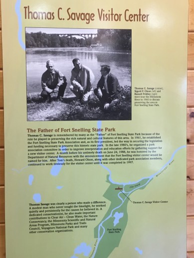
Not far along the park’s entry road is a building where staff collect a fee, $7 per car per day. A bit farther along on the right is the entrance to Picnic Island, and just after that are the parking lot and entrance for the swimming beach. The Thomas C. Savage Visitor Center is farther yet, two miles from the park entrance.

The Visitor Center is a prime location, just below the fort, to begin exploring the site’s historic significance. Just a short walk down a gravel path near the Visitor Center leads to the river shore. Here, where the Mississippi River passes Pike Island, just across a small inlet, is the site where Zebulon Pike camped in 1805, and the landing where the steamboat Virginia anchored in 1823, becoming the first large ship to navigate the river that far.
The lands that provide recreation today were a home for Native Americans for hundreds of years. Dakota villages lined the rivers before the first Europeans set foot here. The Indians hunted, fished, made maple syrup, and gathered for meetings on Wita Tanka, which means Big Island (now Pike Island). The Mde-wa-kan-ton-wan Dakota, “the Dwellers by Mystic Lake” believed the river confluence was the place of origin and the center of the earth.

Today a hiking trail around Pike Island takes visitors to that point where the Minnesota and Mississippi rivers flow together. The Dakota called that place Ha-Ha-Mdo-Te, which means “junction of two rivers.” This is where the town of Mendota got its name.

The more recent experience of the Dakota here was a tragic one. In 1862, 1,600 of them were imprisoned following the U.S.-Dakota conflict in a stockade-like enclosure outside the fort. Between 130 and 300 of them died during the ensuing harsh winter. Outside the Visitor Center is a memorial to those prisoners, Wokiksuye K’a Woyuonihan, “Remembering and Honoring.”

Zebulon Pike–the man both Pike Island and Pike’s Peak were named for–arrived in 1805, exploring the new U.S. territory at the request of President Jefferson. His mission was fourfold: to find the source of the Mississippi River, to buy land, to make peace between the Dakota and the Ojibwe, and to locate a site for a fort. While here, he parleyed two days with the Sioux and obtained 100,000 acres of land nine miles square, extending from the confluence up the Mississippi and including St. Anthony, which is now Minneapolis. According to “The Key to Old Historic Fort Snelling” (Hennepin County History, Winter 1969), the price was $2000, plus $200 worth of presents and sixty gallons of liquor.
The lands surrounding the fort were a vital means of survival for the early white settlers and soldiers who followed Pike and built the fort in the 1820s. “Troops on the frontier were customarily expected to grow large quantities of their own food, and forage for the livestock… Therefore, extensive crops of vegetables, corn and hay, and grain were grown at the post from its beginnings until it was sold in 1857,” according to “A Report: Fort Snelling Historical State Park,” by Harold Raak.

Much activity went on outside the fort walls, such as at the Indian Agency to the southwest. Army officers built houses nearby, farmers set up farms, fur posts located here, and squatters clustered near the fort. Franklin Steele, the Post Sutler who eventually acquired a large swathe of nearby land, built his house near the fort and “entertained on a lavish scale, and much of the social life of the region centered around his home,” Raak says.
As the nation expanded westward in the 1800s, Fort Snelling lost its strategic prominence. It was much used during the Civil War, but by 1870 the “new fort” was being built and the old fort had fallen into decay. In 1946 the fort was decommissioned, which seemed to spell the doom of any plan for restoring the old fort or creating a three-county park at the confluence of the Mississippi and Minnesota rivers, according to Samuel H. Morgan (“Birth, Death and Reincarnation,” Ramsey County History 28:2, Summer 1993).
Morgan, one of the people involved, recounts the story of how these lands became a state park. In 1956 the Minnesota Highway Department proposed building a new bridge with a freeway and cloverleaf interchange on the site of the old fort. This proposal galvanized supporters of restoration, and a tunnel under the site averted the destruction. In 1960 a local landscape architect submitted a proposal, based on a 1934 proposal developed by Theodore Wirth, for a 2,400-acre park. Bills for legislation creating the park were introduced in 1961, but floundered in the face of opposition from local landowners who believed the price offered for their land was too low.

Next, the recently formed Fort Snelling State Park Association did some formidable fundraising. Slowly but surely the park began to become a reality. After much delay the federal government deeded 320 acres of surplus land to the park. The funds raised by the Association often closed the gap between what the state was authorized to pay for surrounding land and the lowest price landowners would accept.
Pike Island was bought in 1965 for $175,000 from Robert Wilkus, whose home there served for a time as the park’s interpretive center.
“The successful staving off of threats to the integrity of the park and its environs has surely been among the most significant accomplishments of the Fort Snelling State Park Association,” Morgan says. “… the most serious threats came from the federal government itself.”

In 1965 the U.S. General Services Administration proposed to build its large new office building on the parade ground. A few years later the Post Office proposed building a huge bulk mail facility there. Quite a few years after that, developers proposed a high-rise that would have blocked the fort’s river view as well as much of its daylight. None of these proposals ever came to fruition, thanks in large part to the strength of the Association.
Such attempted encroachments are to be expected, perhaps, as one of the drawbacks of a choice urban location. Yet the park has prevailed and remains in the middle of the metropolitan area as a testament to St. Paul’s and Minnesota’s past and a source of enjoyment for the 400,000+ people who go there each year.
More information about the park is available by calling any day between 8 a.m. and 4 p.m., either 612-279-3550 or the Visitor Center at 612-725-2724. Or, check http://www.dnr.state.mn.us/state_parks/fort_snelling/index.html for a list of upcoming events. Many events focus on nature, while other events look at the area’s history.
July 2006, revised November 2016 and 2018
